
A longtime leader in forest governance, Gabon has the highest share of land preserved as forest and the lowest rates of tree loss among Congo Basin countries, a climate benefit to the world that the country is now seeking to fund through carbon markets. Accurate measurements of biomass carbon are critical for Gabon’s efforts, to show where carbon in trees and forests is located and how activities like logging and regrowth influence carbon emissions and removals over time.
To date, scientists in Gabon have used conventional field inventory approaches, taking measurements from a few hundred field plots to generate estimates of forest biomass across the country. But ground-based approaches are inherently limited by the availability of plot data and the cost of intensive field campaigns.
Advances in remote sensing and machine learning offer a fast and accurate alternative. A recent study conducted by CTrees researchers under the leadership of Le Bienfaiteur Sagang, a postdoctoral researcher at UCLA’s Institute of the Environment and Sustainability, combined satellite and ground measurements with state-of-the-art machine learning techniques to provide the most detailed and accurate map of live carbon for every hectare of forest across Gabon. The wall-to-wall map for the year 2020 was published in Environmental Research Letters last month.
“This map gives a much clearer picture of exactly how much and where carbon is located in Gabon’s forests,” said Sassan Saatchi, CTrees’ CEO, a research scientist at UCLA IoES and NASA Jet Propulsion Lab/Caltech, and a co-author of the study. “The map provides Gabon with a baseline that can be used to monitor carbon and access climate finance.”
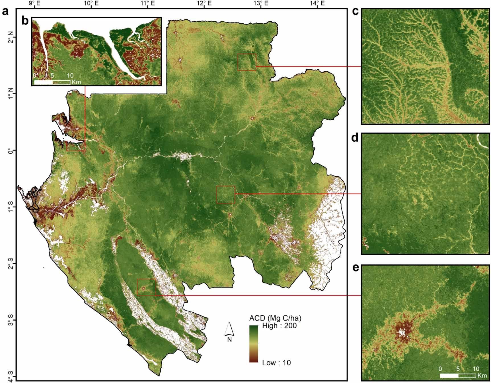
Map of aboveground carbon density of Gabon's forests at 1-hectare resolution, including (b) tall mangroves of Pongara National Park, (c) flooded forests, (d) degraded forests within logging concessions, and (e) secondary forests along urban areas.
The researchers found that 4 billion tons of live carbon was stored in Gabon’s forests in 2020, and the country’s managed forests had a live carbon density that was 20 percent higher on average than its unmanaged ones.
Logging concessions cover about 64 percent of Gabon’s area and contain 68 percent of the country’s total live carbon, according to the study. There, the combined effect of selective logging of high-value trees and the relatively long rotation cycles, the period of time between harvests, support the maintenance of high carbon storage and density. In addition, forest regrowth following selective logging can contribute to higher rates of carbon recovery.
The new carbon map is highly accurate, with an estimated nationwide average carbon density which is less than one percent different from reference datasets available over the country. The map outperforms all global biomass datasets in resolution and accuracy, suggesting carbon maps produced at the national level can be readily integrated in the country's reporting commitments to UNFCCC.
“Our results show the importance of integrating in-situ datasets into large-scale carbon maps,” said Sagang. “With this approach, we built the most accurate living carbon estimates for every hectare of forest across Gabon. This study is an invitation to countries across the Congo Basin to develop similar efforts of mapping forest carbon.”
For Sagang and the research team, the study demonstrates the power of remote sensing and machine learning techniques to develop frequent, accurate, and cost-efficient carbon measurements for all countries in the Congo Basin which lack consistent plot systems. Such estimates are the basis for achieving high-quality national greenhouse gas inventories that meet IPCC standards, support development of nationally determined contributions to the Paris Agreement, and underpin access to carbon market finance.
The scientists’ next step is to develop a clearer accounting of annual emissions and removals in the Congo Basin by combining the carbon data with information on activity like logging, deforestation, and forest regeneration.
The research was funded by the U.S. Forest Service, and involved the collaboration of Gabonese institutions including the Agence Nationale des Parcs Nationaux (ANPN), Agence Gabonaise d’Etudes et d’Observations Spatiales (AGEOS), Centre National de la Recherche Scientifique et Technologique (CENAREST), and Ministère des Eaux, des Forêts, de la Mer, de l’Environnement (MINEF), with U.S. research partners at the UCLA Institute of the Environment and Sustainability, and NASA’s Jet Propulsion Lab.


