
Agriculture drives 90% of tropical forest loss. In response, the European Union’s Deforestation Regulation (EUDR) marks a historic shift, bringing legally binding requirements to address deforestation in agricultural commodity supply chains. Demand-side regulations like EUDR create powerful incentives for scaling the deforestation-free commodity market.
Under EUDR, companies importing seven categories of commodities to the EU must trace products to the exact plot of production and prove the imported goods are both free of deforestation and compliant with local laws. Implementing the law requires companies to apply remote sensing science and technology to answer important questions: are there forests in commodity supply chains, where (and when) is deforestation occurring, and how should entities communicate and verify the evidence.
EUDR compliance is further complicated by the diverse actors involved—companies, enforcement authorities, downstream buyers, and smallholders—each with different capacities and needs. While companies can draw on reference maps and third-party service providers to support their due diligence, the legal responsibility for compliance ultimately rests with the companies themselves.
This blog explores key questions raised by these dynamics:
- How accurately do remote sensing solutions classify forest and non-forest lands, and detect change over time?
- How are different stakeholders, including producers, enforcement authorities, and downstream buyers impacted by the use of remote sensing data in the compliance process?
- What innovations can improve accuracy and transparency while reducing compliance costs?
Public Remote Sensing Underpins EUDR Monitoring, But Critical Gaps Remain
Remote sensing science is essential for delineating and monitoring forests under the EUDR. It relies on technologies developed since the mid-1980s, such as satellites and airborne sensors, to map and quantify changes in land over time.
Public remote sensing data forms the backbone of EUDR implementation. These datasets—typically provided by space agencies, environmental organizations and research institutes—classify forests, croplands, and other land cover types, and track changes over time. However, their temporal resolution and forest definitions may not always align with specific requirements of the EUDR.
EUDR monitoring solutions typically combine public datasets to build tailored composite maps specifically for compliance. For example, the European Commission’s Joint Research Centre (JRC), a scientific arm of the European Commission, produces a global forest map that integrates nearly 30 public datasets. Most commercial EUDR monitoring solutions follow a similar approach, leveraging existing data to meet regulatory needs.
Still, current solutions are far from perfect. The JRC map, while valuable, is intended for reference and holds no legal authority. Meanwhile, other global forest cover maps—produced by research institutions and academic groups—may offer higher accuracy or resolution in specific regions, providing helpful alternatives but also creating confusion among users.
EUDR’s Definition of “Forest” Creates Technical Challenges
EUDR introduces a globally uniform forest definition to streamline remote sensing monitoring and avoid inconsistencies across countries. However, this standard creates three major technical challenges for remote sensing applications:
1. Mismatch between the EUDR forest definition and remote sensing capabilities
EUDR draws heavily from the FAO definition: forested areas must cover at least 0.5 hectares, with a canopy density above 10% and tree height over 5 meters. But this definition was originally designed for field surveys—not satellite data.
Most public remote sensing datasets have pixel resolutions of 10 to 30 meters, finer than the 0.5-hectare threshold (roughly 70×70 meters). To bridge this gap, JRC uses post-processing algorithms that "fill in" small gaps within the 0.5-hectare unit. This approach can miss small-scale deforestation patches and obscure subtle differences in the landscape, blurring the line between forests and sparsely wooded areas.
Tree height thresholds—like the 5-meter rule in EUDR—pose a problem for satellite-based monitoring, which struggles to reliably map tree height. Forcing satellite data to fit the EUDR definition often results in misclassification, fueling tensions between the EU and producer countries.
2. Differentiating forests from trees on agricultural land
Not all tree-covered land qualifies as forest. Many agricultural landscapes contain trees, but they do not meet the definition of forest under EUDR. The regulation considers both land cover and land use. While remote sensing can identify land cover, it cannot directly observe how the land is used. Determining land use requires analyzing imagery over time and incorporating additional contextual data to make accurate attributions.
In particular, remote sensing faces difficulties in distinguishing agroforestry systems, small plantations from natural forests, especially in mosaic landscapes where diverse land uses coexist. Tree crops, such as shaded cocoa, coffee, old-growth oil palm, and natural rubber, often exhibit spectral signatures that closely resemble those of natural forests. As a result, remote sensing-based maps may misclassify these tree-rich agricultural systems as forest, creating unintended compliance burdens for farmers and increasing the risk of exclusion from supply chains.
3. Challenges identifying young secondary forests
Secondary forests—those naturally regenerating after disturbance from human or natural events —are climate-critical ecosystems. They have the potential to sequester significant amounts of carbon rapidly before reaching maturity. In Brazil, the area of young secondary forests (under 10 years old) rivals that of primary forests across the Arc of Deforestation. In recent years, secondary forests of various ages have been repeatedly cleared for agricultural expansion, land speculation, and tenure conflicts. The EUDR counts these areas as forest, meaning clearing them for agriculture is considered deforestation.
But satellite systems often struggle to detect young forests under 10 years old, as the tree height and canopy density may vary depending on land use history and local conditions, and may not meet the EUDR thresholds. Regenerating forests are also easily confused with fallow land in shifting agriculture systems, making classification even harder.
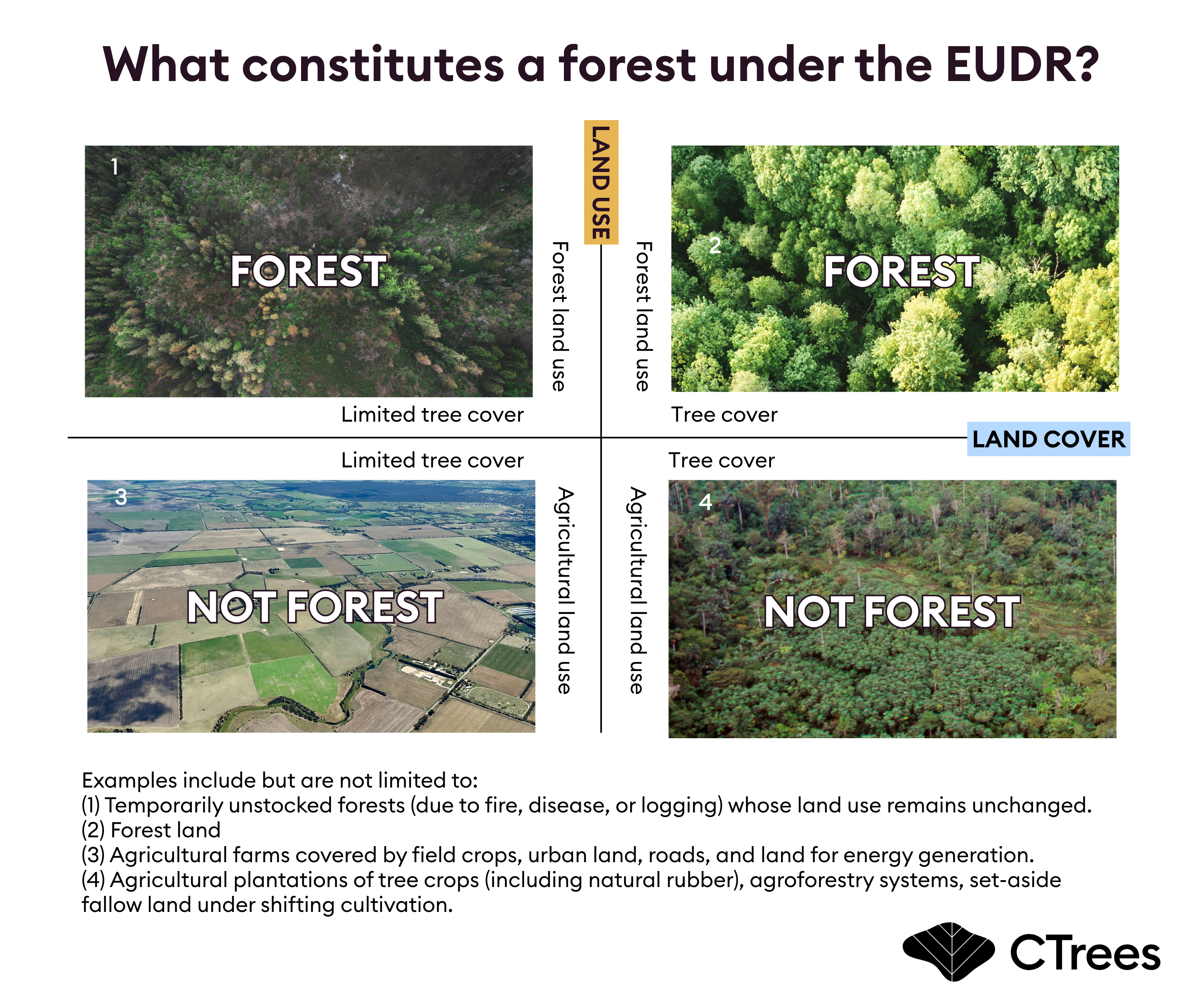
EUDR defines forest according to both land cover and land use, presenting ongoing challenges for remote sensing-based monitoring.
Existing Remote Sensing Solutions Raise Equity and Transparency Concerns
Challenges associated with EUDR’s uniform definition of forest often lead to imprecise forest maps, requiring companies and their service providers to manually validate plots flagged as potential deforestation. The process typically involves analysts visually interpreting high-resolution satellite imagery or on-the-ground agents collecting field data.
While manual validation is an essential final step to confirm deforestation, overreliance on the technique can have unintended consequences. Current data processes are falling short for key stakeholders:
- For downstream companies, liability does not end at the point of import. They are jointly liable for due diligence conducted by their upstream suppliers. In higher-risk cases, downstream companies may want to take further steps to examine the upstream due diligence systems. Joint liability is essential for reducing potential loopholes in enforcement. Yet few commercial monitoring providers offer transparent methods or rigorous accuracy metrics for EUDR solutions. Without this information, companies may struggle to evaluate the reliability of manual validation processes. This opacity increases the risk exposure of companies down the value chains.
- For enforcement authorities, oversight is complicated by the fact that companies are not required to submit direct evidence of deforestation in their due diligence statements. Instead, national authorities must primarily rely on public forest maps, which, as discussed, have known limitations. Since EUDR mandates checks on only 1-9% of regulated companies, even small errors in these maps can significantly undermine enforcement by allowing instances of noncompliance to go undetected.
- For smallholder farmers, misclassification of farms as forest can be particularly harmful. If correcting these errors relies on manual efforts, farmers face a higher compliance burden to demonstrate conformity with EUDR requirements. This, in turn, may lead companies to view sourcing from smallholders as riskier or more costly. The unintended consequence is potential exclusion from global commodity markets—especially for smallholders practicing agroforestry or farming in mosaic landscapes, where the risk of misclassification is disproportionately high.
These challenges are real and consequential for many stakeholders. If left unaddressed, they could slow the growth of deforestation-free commodity markets. The good news is that a better approach to monitoring is within reach — one that is more inclusive, more transparent, and more scientifically rigorous.
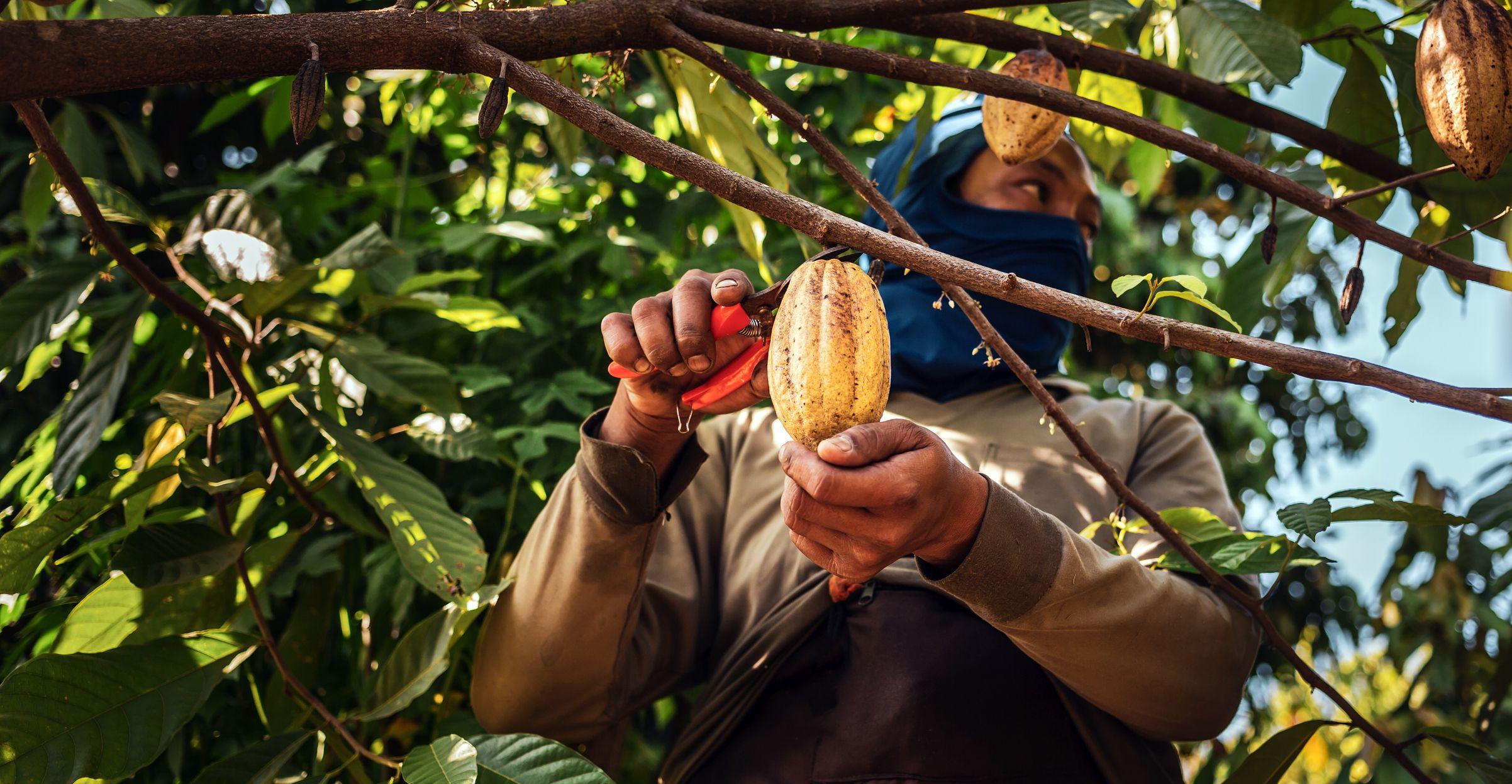
Smallholder farmer harvesting cacao fruits in Thailand (Photo credit: Narong KHUEANKAEW/iStock).
Building Smarter Monitoring Systems For Zero-Deforestation Commodities
EUDR is raising the bar on combating deforestation in agricultural commodity supply chains. But meeting its requirements depends on more than just one dataset. As JRC emphasizes in its latest 2025 report: no single map can tell the full story.
The JRC’s forest map provides a valuable starting point, but companies should proceed with caution. A parcel flagged as forest today could reflect an error such as trees on agricultural land—or areas that will never actually be deforested. Instead of cutting these areas from supply chains outright, companies should treat them as “under observation,” and use continuous monitoring to better understand what’s really happening on the ground.
CTrees proposes a tiered approach to monitoring deforestation in supply chains. This begins with global forest maps—such as the ones developed by the JRC—to identify forested versus non-forested areas. Forested plots are then continuously monitored using near-real-time alert systems, enabling early intervention by companies when disturbances are detected.
Companies can choose to act immediately or refine their focus using contextual filters to narrow down areas requiring follow-up. High-resolution land cover change data offers state-of-the-art accuracy in detecting small-scale clearances and complements this process. Finally, analysts conduct visual interpretation of very-high-resolution imagery to determine whether the observed changes qualify as deforestation under the EUDR definition.
The tiered approach reduces the need for manual validation and enables companies and authorities to detect deforestation with greater speed, precision, and confidence.
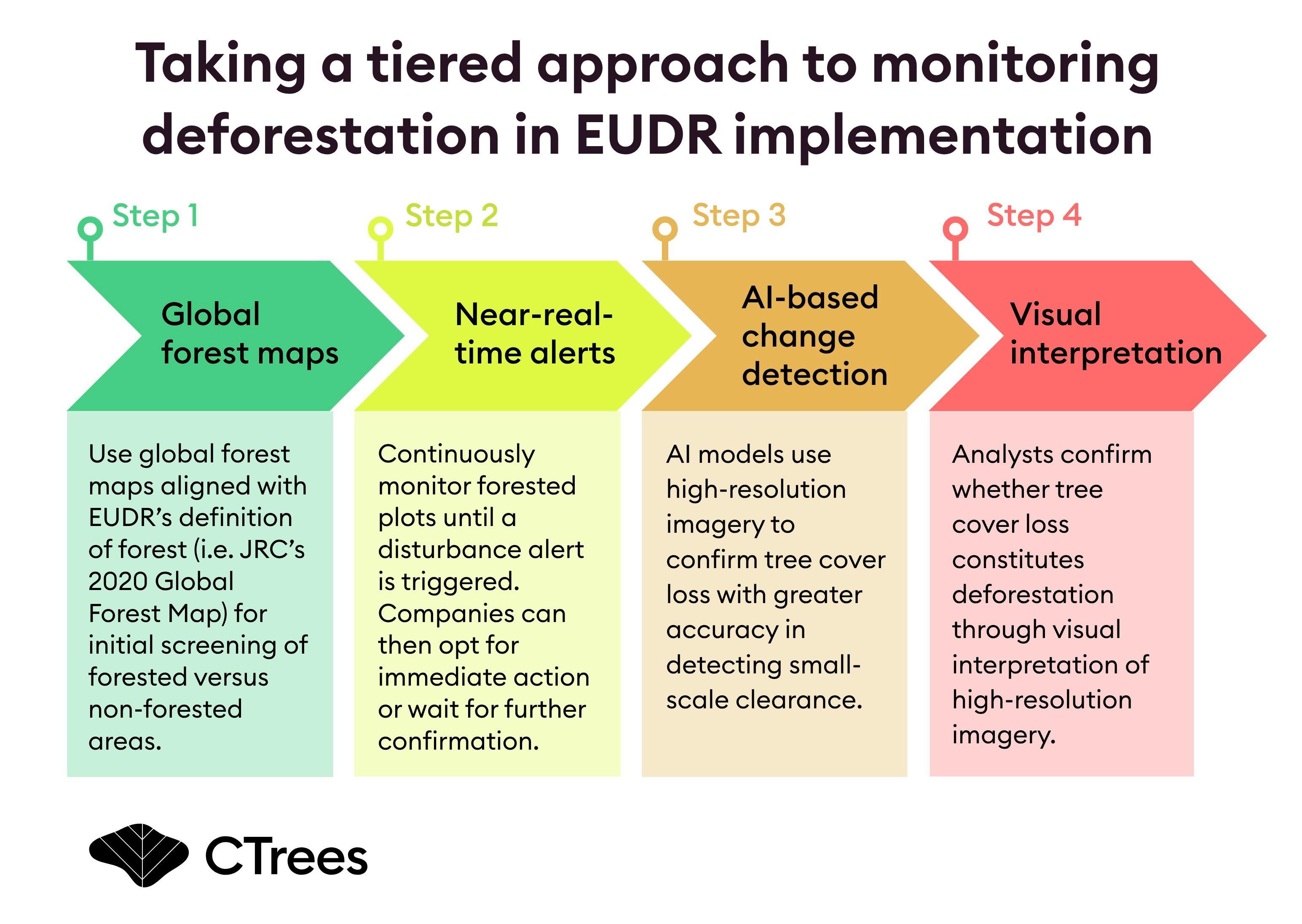
We identify three opportunities to integrate advanced technologies such as artificial intelligence and cloud computing to realize this new approach:
Go local: Build public agroforestry maps
Progress is being made in distinguishing trees on agricultural land from natural forests with remote sensing tools. This advancement is driven by the integration of satellite imagery with on-the-ground observations and historical land use data. What’s needed now are regionally tailored remote sensing models that combine AI capabilities with local expertise.
New regional maps of agroforestry systems and tree plantations should be treated as public goods—integrated into global forest maps in the first step. More accurate, open-access maps help reduce classification errors at scale. This is especially critical for smallholders, who are often disproportionately affected by mistaken forest classifications that jeopardize their access to global markets.
Prioritize timeliness over rigid adherence to definition in continuous monitoring
The global forest maps used in the first step provide a static snapshot from a single year, limiting their ability to capture ongoing changes. This is where near-real-time alerts like CTrees’ LUCA platform add value, delivering timely updates that help businesses respond to emerging deforestation risks faster. In practice, continuous monitoring should prioritize precision over rigid adherence to forest definitions. Forcing advanced technologies to fit definitions can dilute the unique strengths of modern remote sensing tools—each brings complementary capabilities to the global forest maps aligned with the EUDR definition.
Continuous monitoring isn’t just about meeting regulatory requirements—it also strengthens supply chain resilience. By extending monitoring beyond large plantations to include smaller farms with forest remnants, companies can build a broader, traceable, and better-monitored supply shed. This not only supports EUDR compliance but also helps cushion against harvest disruptions. More importantly, the monitoring data for the same supply shed can be repeatedly used for compliance reporting, enabling companies to take full advantage of simplification measures such as consolidated annual reports. This reduces administrative burdens and lowers overall compliance costs.
Layer human insight on top of high-resolution data
At the final stage of the EUDR monitoring system, human analysts play a critical role. Validation of plots flagged as potential deforestation is essential, but it is also costly and time-consuming. Visual interpretation carries significant uncertainty, often depending on the analyst’s expertise and familiarity with local forest characteristics and satellite data interpretation. Meanwhile, very high-resolution satellite imagery (with pixel spacing under 5 meters) is not always available with the needed frequency or geographic coverage. Ground-based field verification, while valuable, adds further costs and logistical complexity.
AI can play a vital role in reducing the manual work required here. AI-based models using data at 5-10 m resolution can detect small-scale clearances that might otherwise go unnoticed. CTrees provides tropical forest loss data at 5m resolution through its REDD+AI platform, and at 10-m resolution through its LUCA platform, both designed to flag tree loss through human induced disturbance.
Human analysts can step in after a plot is flagged by both near-real-time alerts and AI-based change detection. The analyst assesses whether the observed changes are likely to represent actual deforestation. For example, events larger than 4 hectares might be prioritized for review, where visual interpretation benefits from significantly reduced uncertainty. This layered approach—using AI for scale and precision, and human expertise for contextual insight—enables more targeted and efficient monitoring across complex supply chains.
The Future Of EUDR Compliance Depends On Smarter Monitoring Systems
A tiered approach—combining satellite imagery, AI analysis, and human interpretation—offers a clear, scalable pathway. It reduces classification errors, protects smallholders, strengthens supply chain resilience, and lowers compliance costs. This is more than a regulatory obligation. It’s a blueprint for building transparent, inclusive, and deforestation-free supply chains—fit for the future.


