
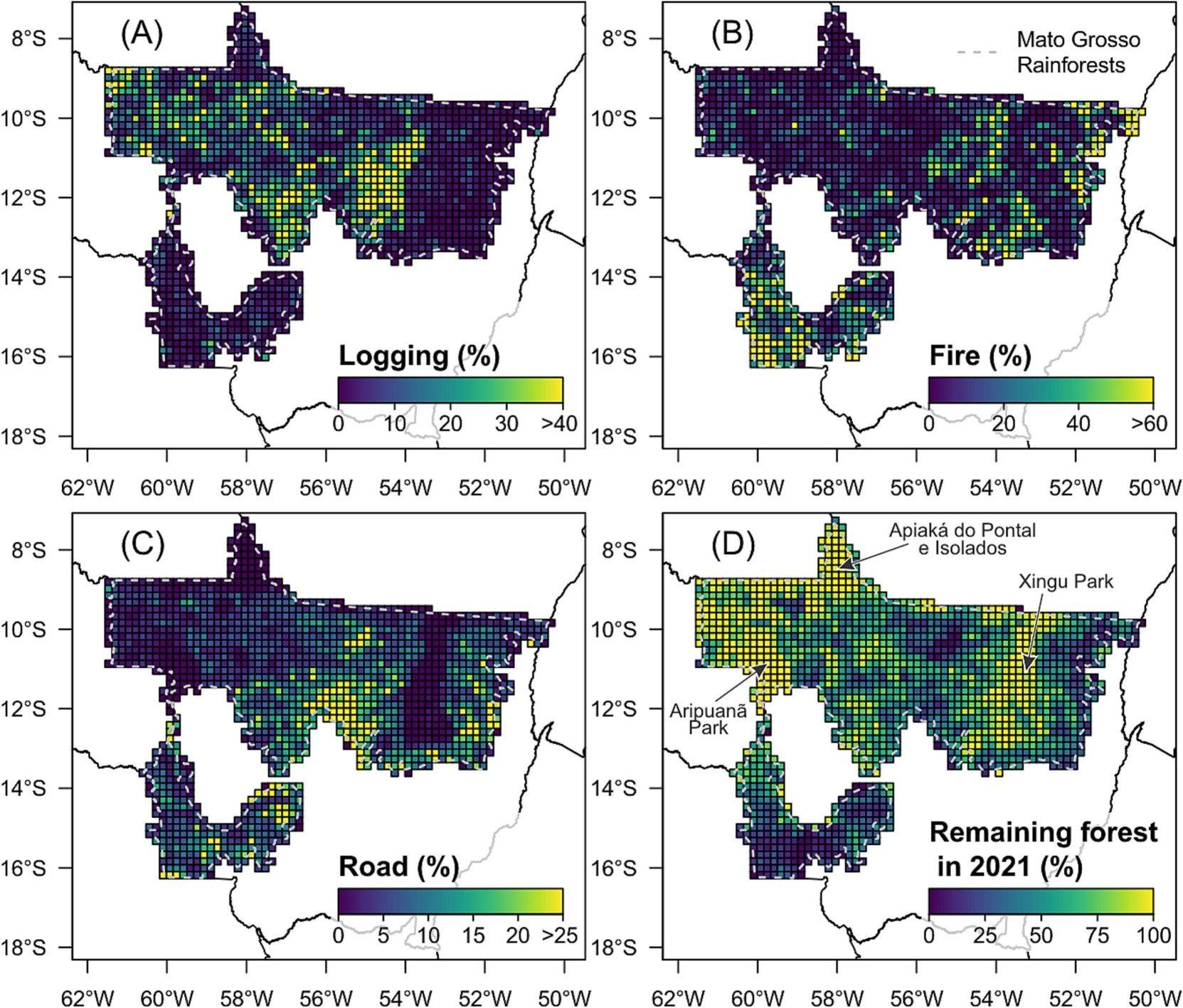
Percentage of degraded forests from 2016 to 2021 shown by the deep learning product for disturbances caused by (A) logging, (B) fire, and (C) road construction. Panel (D) represents the percentage of remaining intact forests in the year 2021.
CTrees scientists have achieved a breakthrough in applying deep learning techniques to automatically measure tropical forest degradation, the small-scale effects of logging, fire, and roads, that are cumulatively the largest form of forest disturbance in the tropics and, in the Brazilian Amazon, the largest source of carbon emissions from land use.
The paper in Remote Sensing of Environment from lead author Dr. Ricardo Dalagnol, research scientist at CTrees and a postdoctoral researcher at UCLA’s Institute of the Environment and Sustainability, demonstrates how to map and quantify tropical forest degradation using a deep learning model and data from the PlanetScope satellite constellation, provided by Planet Labs PBC and made available via Norway’s International Climate and Forests Initiative (NICFI).
The new model achieves a level of accuracy similar to human interpretation of satellite images and precisely attributes degradation from logging and other disturbance. To date, scientists have struggled to apply remote sensing techniques to map small-scale disturbances like selective logging.
Dr. Sassan Saatchi, CTrees’ CEO said, “This study addresses a major gap in monitoring change in forests. This is the first automatic method capable of accurately mapping logged and burned forests, and it is the first method that disentangles logging from other disturbances. The study opens the possibility of cost-effective annual monitoring of degradation across the tropics, which will support efforts to protect and restore forests as a climate solution.”
The paper presents the process of training and validating a deep learning model to map forest degradation with distinct attributions to logging, fire, and road construction. The scientists tested the model in the Brazilian state of Mato Grosso, finding that the combined effects of logging and fire are degrading remaining intact forests at an average rate of 8,443 km2 per year from 2017 to 2021. In 2020, a record degradation area of 13,294 km2 was estimated from the model, twice the area of deforestation that year. The CTrees maps outperformed all other operational data products in mapping logging and fire, when compared to official Brazilian data. The deep learning model’s results were similar to a trained human delineating the effects of logging and fire by hand on satellite images.
Degradation from selective logging and forest fires are the dominant form of disturbance in tropical forests, and degradation accounts for 42% of total gross carbon emissions of the land use sector in the Amazon (compared to 34% from deforestation and 24% from droughts).
Following the successful demonstration in Mato Grosso, Dr. Dalagnol and the CTrees science team are now testing the method in all tropical forest regions, with the goal of releasing data next year to inform governments and organizations working to protect and restore tropical forests.
Dr. Ricardo Dalagnol, lead author of the study, said “With this degradation model in hand, we can now apply the method across the tropics to quantify the full effects of degradation for the first time – including an accurate estimate of degradation’s impact on carbon emissions. The data will help us know when, where, and how much degradation is occurring, so interventions can be targeted against this significant source of emissions.”
Co-authors of the paper include CTrees scientists and advisors Fabien Wagner, Fiona Osborn, Le Bienfaiteur Sagang, Celso H. L. Silva-Junior, Samuel Favrichon, Liana Anderson, Luiz Aragão, Rasmus Fensholt, Martin Brandt, Philippe Ciais, and Sassan Saatchi.


