
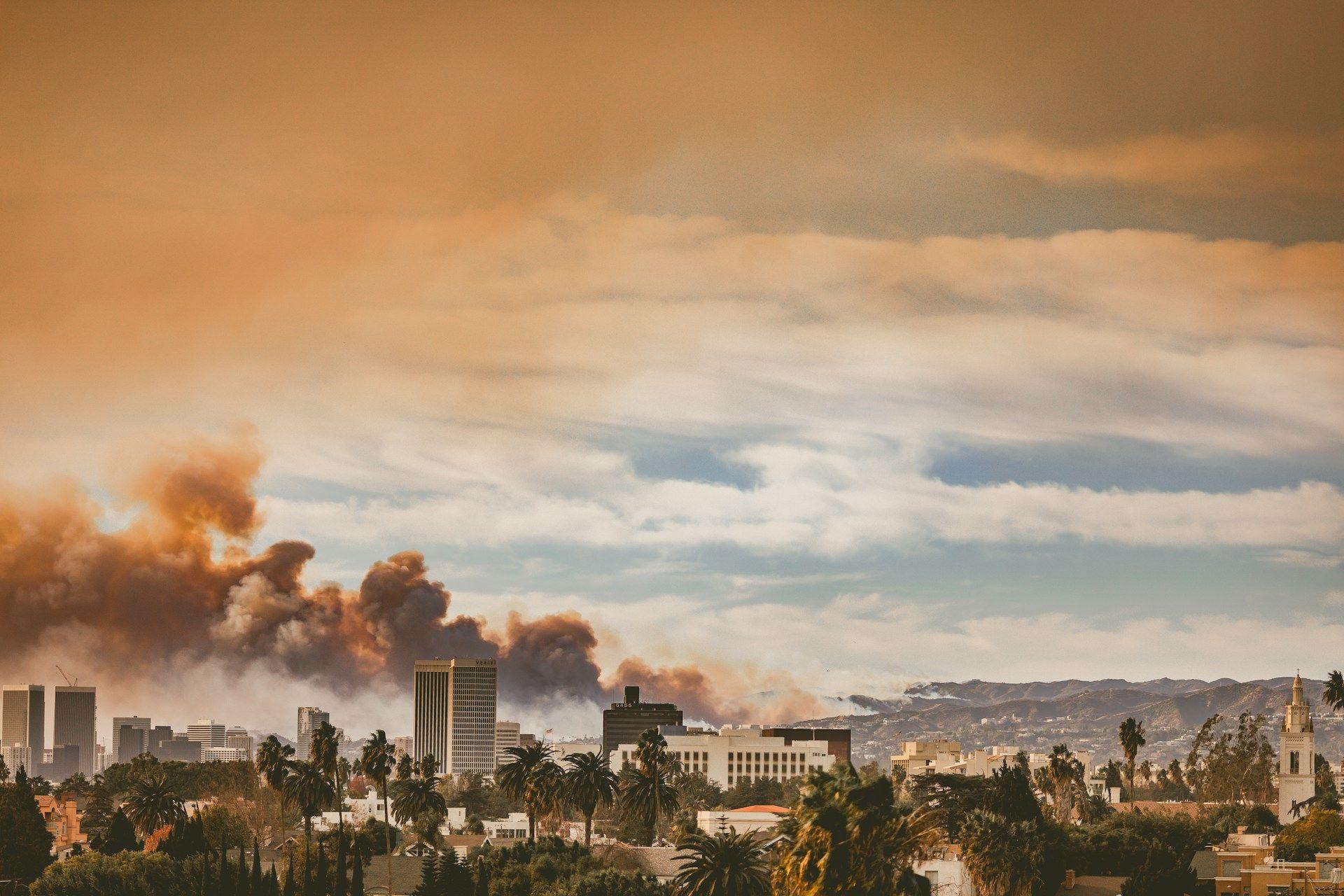
View of the Eaton Fire from Koreatown, Los Angeles, on Jan. 9, 2025. Photo credit: Jessica Christian.
For many California residents, the looming threat of wildfires is nothing new. The Camp Fire (2018), North Complex Fire (2020), and Dixie Fire (2021) are just a few of the recent California wildfires etched into our collective memories.
Fundamentally, to live in California is to live alongside fire—but in the last few years, this relationship has become increasingly perilous.
Across the state, fires are becoming faster, larger, and more destructive. As climate change makes periods of drought more frequent, it also leads to more intense wildfires. Seven of the 10 largest wildfires in California history have occurred since 2020.
Forest fires have a significant impact on California’s ability to meet established climate targets, with fires in 2020 causing more than 173 megatons of carbon dioxide equivalent emissions, according to CTrees data, an amount roughly equivalent to the state’s average annual emissions from transportation.
Although the recent Palisades and Eaton fires are not the largest wildfires in the state’s history, they are shaping up to be among the most destructive. The two fires tore across nearly 37,000 acres, destroyed over 16,000 structures, killed 30 people, and displaced thousands. Early estimates for damage and economic loss from the fires sit at over $250 billion, making the conflagrations one of the most expensive natural disaster events in U.S. history.
For many Los Angeles residents, watching these fires consume entire neighborhoods in real-time felt both terrifying and incomprehensible. Now, with residents and officials focusing attention on efforts to rebuild, many are left wondering: in an era of climate crisis, are wildfire disasters like this destined to be the new normal? And if so, what can we do to mitigate the worst of their impacts?
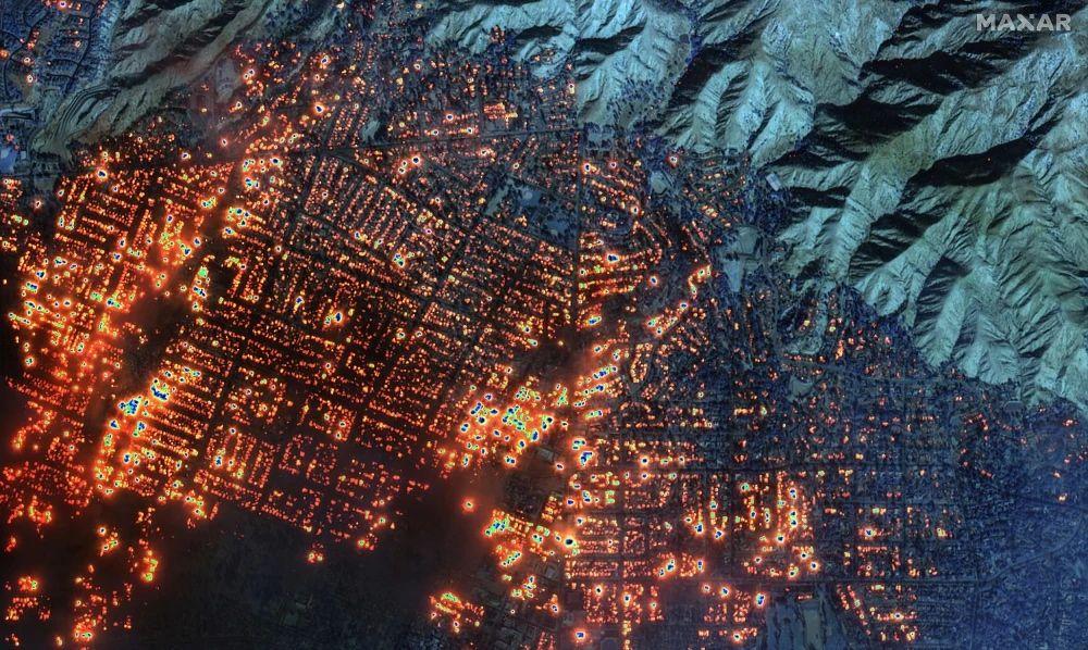
Satellite imagery from Maxar Technologies shows scale of the Eaton fire in Altadena, California (Jan. 2025).
The distinction of disaster
At a recent talk on the Los Angeles wildfires hosted by UCLA’s Institute of the Environment and Sustainability, Crystal Kolden, an assistant professor and fire scientist at UC Merced who began her career as a wildland firefighter for the U.S. Forest Service, made a striking observation: area burned globally is declining, but extreme wildfire events are increasing—and California has become a hotspot.
The escalating impact of droughts, exacerbated by climate change, combined with the state’s historic reliance on fire suppression policies, proliferation of invasive species, and significant changes to development patterns have left many communities across California in a vulnerable position. Neighborhoods situated in the wildland-urban interface, like the Palisades and Altadena, are particularly at risk from frequent and nearby fires.
But the presence of wildfire, in and of itself, does not constitute disaster. California’s landscapes have long been shaped by fire. In fact, many of its ecosystems are largely dependent upon it.
Decades of research have shed light into the important role of fire in Southern California’s ecosystems. Chamise chaparral, coastal sage scrub, and live oak woodland—the dominant vegetation across the Santa Monica mountains—are just a few of the plants that rely on wildfire cycles to recycle nutrients and ensure seed germination.
“We don’t want to stop the fires, we want to prevent the disaster,” Kolden said during her talk. “The disaster is the fatalities, the disaster is escape routes getting cut off and people panicking because they can’t evacuate, the disaster is thousands of houses burning down.”
As Kolden suggests, a continued policy of total fire suppression is not a viable path forward, nor is it one that will prevent death and destruction. Rather, fire suppression builds up fuel stocks and drives more catastrophic fires.
Likewise, managed retreat—a planning practice that involves government buyouts and moving communities away from areas deemed at high risk of environmental threats—is not a feasible solution. An estimated 44 million houses nationwide are situated in the wildland-urban interface and thus subject to greater risk from potential wildfires. Managed retreat on that scale is not only unprecedented, it is essentially impossible.
So how can communities in California and elsewhere manage persistent threats from seemingly unavoidable wildfires?
Lis Koslov, professor of urban planning at UCLA, and Kathryn McConnell, professor of sociology at the University of British Columbia, insist in a recent New York Times op-ed: “Rather than dream we can retreat our way out of the crisis, we must relearn, and learn anew, how to live with fire.”
(Re)learning how to live with fire
As Los Angeles transitions from emergency response to long-term recovery efforts, we must critically reevaluate the decisions, practices, and policies that have made so many of our communities so vulnerable to large-scale wildfire disasters.
“I have heard many many times in the last few weeks…'Nothing could have stopped these fires,'” Kolden said in the final minutes of her talk. “And I think to myself: no, there are things that could have stopped these fires in terms of having the preparation done, the mitigation work done ahead of time.”
If Californians are to (re)learn how to live with fire, then our collective mindset must shift from that of resistance to resilience. There is no shortage of strategies to do so: elevating indigenous knowledge, implementing firebreaks, improving hazard maps and fire modeling, and solidifying community evacuation plans are just a few of the many concrete actions that cities like Los Angeles can take to promote fire resilience and prevent future harm.
On a statewide level, there are significant gaps in forest mapping and monitoring that need to be addressed.
Better data for better fire management
Forest fuels, or the organic matter available for fire ignition and combustion, are one particularly important factor in fire management. The availability of this fuel – or lack thereof – largely dictates the destructiveness of wildfires.
As Richard Minnich, a leading authority on chaparral brushfire, noted in Mike Davis’ “The Case for Letting Malibu Burn,” “fuel, not ignitions, causes fire. You can send an arsonist to Death Valley and he’ll never be arrested.”
Although forest fuels are directly linked to measurements of forest height and biomass, accurate and timely data on these measurements have long been difficult to obtain. Existing maps of forest height and biomass across California are relatively coarse in resolution, with a large degree of uncertainty that makes the data challenging to apply to more localized forest management plans.
Since 2022, CTrees researchers and their scientific partners have been working to change that.
Applying innovations in remote sensing and deep learning, CTrees scientists have successfully mapped all individual trees across the Western states, including the entirety of California. CTrees has developed tree canopy cover, tree height at sub-meter resolution, and dry aboveground biomass maps at the scale of quarter acre to accurately quantify the fuel loads across the wildland-urban interface.
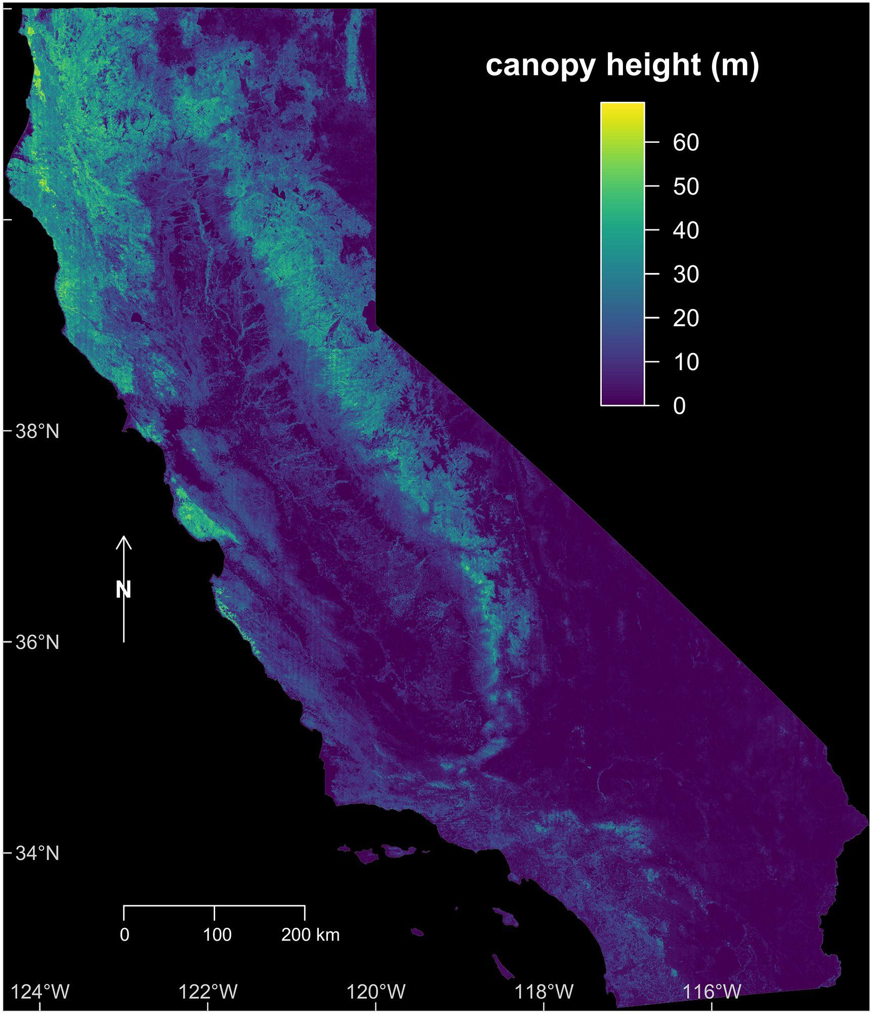
Canopy height map of California shows the distribution of tree heights across the state.
In a recent study, Samuel Favrichon, a postdoctoral researcher who worked with CTrees’ CEO Sassan Saatchi at NASA Jet Propulsion Laboratory, combined LiDar data, satellite imagery, and deep learning models to map tree canopy height across California. The study found that fire caused more than 60% of the state’s large forest disturbances during the observation period—highlighting the significant impact of fire on California forests.
CTrees’ cutting-edge research demonstrates the ability of locally trained deep learning models to map forest structure at a higher resolution and with greater accuracy than existing monitoring systems. Applied broadly, the approach could rapidly modernize forest management in California and across the greater United States.
Choosing California as the early focus of CTrees’ research is no coincidence. The state’s forests are home to some of the largest tree species on Earth, with some of the greatest biomass in the world. If researchers can develop deep learning models that accurately predict tree-level characteristics across the highly diverse biomes of California, then they can map forests almost anywhere.
“Our approach to mapping change across the state's forests has implications far beyond California,” said CTrees scientist Fabien Wagner. “The success of our locally trained models can be replicated across the United States, paving the way for more informed policy-making and forest management strategies that protect these essential ecosystems.”
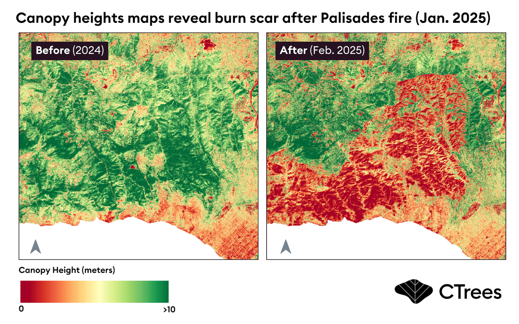
The potential impact of CTrees’ research and data on forests is significant, particularly when integrated into models for fire prediction and decision support systems. Accurate and frequent tree-level data can enhance mitigation and adaptation planning efforts. This information can also shed light on the extent of damage to forest structure following major fires.
Ultimately, better mapping and monitoring of our forests means better forest management, and a greater ability to mitigate risk from future wildfires.
A call to action
Wildfires are an essential part of California’s landscape, but the disasters that follow—the loss of life, destruction of communities, and economic devastation—are not.
The historic fires that swept across Los Angeles in January serve as a distressing but timely call to action: in the years to come, we must (re)learn how to live alongside fire.
Recent advancements in science and technology, led by CTrees researchers, can improve fire risk assessments and inform better decision-making in California and beyond. Accurate and timely forest data can help to identify target areas for wildfire fuel reduction, advancing mitigation efforts and reducing the scale and speed of inevitable fires to come.
If embraced, new forest management practices and policies can help us move from a state of resistance to resilience—ensuring that when a new fire starts, disaster does not follow.


